The 2025 Atlantic hurricane season continues to show signs of activity as the National Hurricane Center (NHC) reports a cluster of disorganized thunderstorms in the northwestern Caribbean Sea. According to official forecasts, these storms are expected to consolidate, forming a well-defined center of circulation later today or tonight. Once organized, the system could be named Helene and may track through the Yucatan Channel before intensifying into a hurricane in the Gulf of Mexico.
While the storm is still in its formative stages, meteorologists are closely monitoring its development due to the potential impacts on coastal communities, marine activities, and inland areas. This article provides a detailed overview of the situation, the science behind tropical cyclone formation, historical context, and practical advice for residents in the storm’s potential path.
Current Status and Forecast
Observations from the National Hurricane Center
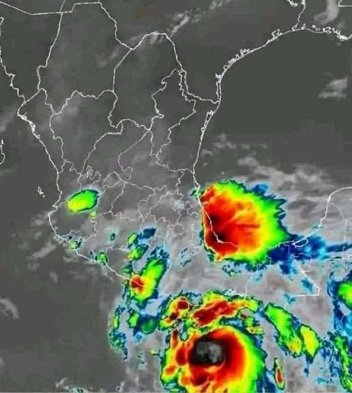
As of the latest update, the system in the northwestern Caribbean is primarily a cluster of disorganized thunderstorms. Satellite imagery shows convection spreading across a wide area, but the system has yet to consolidate into a single, cohesive circulation.
The NHC forecasts that, given favorable environmental conditions—such as warm sea surface temperatures, low wind shear, and ample moisture—the storm could develop a closed low-level circulation, the hallmark of a tropical cyclone, later today or tonight. Once this occurs, the system would be officially classified as Tropical Storm Helene.
Expected Track
Forecast models suggest the storm will move northwest toward the Yucatan Channel, the narrow strait separating Mexico’s Yucatan Peninsula from western Cuba. After passing through the channel, conditions in the southern Gulf of Mexico—warm waters exceeding 28°C (82°F) and low vertical wind shear—could allow Helene to intensify further, potentially reaching hurricane status.
Uncertainty in Forecasts
It is important to note that tropical storm forecasting is inherently uncertain, particularly during the early stages of development. Small changes in wind patterns, sea surface temperatures, or atmospheric moisture can significantly alter the storm’s path and intensity. The NHC continues to monitor the system hourly, updating the public as conditions evolve.
How Tropical Storms Form
Understanding the potential development of Helene requires a basic knowledge of tropical cyclone formation.
Ingredients for a Tropical Storm
Tropical storms develop under specific conditions:
- Warm Sea Surface Temperatures (SSTs) – Typically above 26.5°C (79.7°F), providing the energy needed to fuel convection.
- Moisture in the Mid-Troposphere – Sufficient humidity allows thunderstorm clouds to develop and strengthen.
- Low Vertical Wind Shear – Strong differences in wind speed or direction at different altitudes can disrupt storm organization.
- Preexisting Disturbances – Most tropical storms begin as clusters of thunderstorms or tropical waves.
- Coriolis Force – This force, resulting from Earth’s rotation, enables the storm to develop rotation; it’s why storms rarely form near the equator.
Once these conditions align, thunderstorms begin to consolidate around a central low-pressure area, drawing in warm, moist air. As the air rises, it cools and condenses, releasing heat that further powers the storm—a self-reinforcing cycle that can lead to rapid intensification under the right circumstances.
Naming Tropical Storms
Once the NHC confirms a storm has developed a closed circulation and sustained winds of at least 39 mph (63 km/h), it is assigned a name from the predetermined list for the season. In 2025, the storm is expected to be named Helene.
Naming storms helps:
- Communicate risks to the public more effectively.
- Avoid confusion when multiple storms occur simultaneously.
- Simplify news reporting and emergency messaging.
Historical Context: Hurricanes in the Caribbean and Gulf of Mexico
The northwestern Caribbean and Gulf of Mexico are historically high-risk areas for tropical cyclones.
Past Hurricanes
- Hurricane Wilma (2005) – One of the strongest Atlantic hurricanes on record, it formed in the Caribbean and struck the Yucatan Peninsula before moving into the Gulf of Mexico.
- Hurricane Michael (2018) – A Category 5 hurricane that rapidly intensified in the Gulf, causing extensive damage in Florida.
- Hurricane Isidore (2002) – Formed in the Caribbean, crossed the Yucatan, and affected the Gulf Coast with heavy rainfall and flooding.
These events demonstrate that early monitoring is crucial, as storms can intensify rapidly once they enter the Gulf due to warm waters and favorable atmospheric conditions.
Potential Impacts
Even as a tropical storm, Helene could pose multiple risks to communities in its path.
Wind Damage
- Sustained winds of 39–73 mph could down trees, power lines, and weaken poorly constructed buildings.
- If Helene intensifies to a hurricane, winds exceeding 74 mph could cause severe structural damage and widespread power outages.
Storm Surge
- Coastal areas, particularly along the Gulf of Mexico, are vulnerable to storm surge, which is the rise of seawater pushed ashore by the storm’s winds.
- Storm surge can inundate low-lying areas, disrupt transportation, and damage property.
Rainfall and Flooding
- Heavy rain associated with tropical storms can lead to flash flooding, especially in urban areas or regions with poor drainage.
- Inland flooding remains a significant risk even if the storm weakens before landfall.
Marine Hazards
- Swells and rough seas will affect shipping routes and recreational boating.
- Warnings for mariners are likely to be issued by the U.S. Coast Guard and regional authorities.
Safety and Preparedness
Residents in the Caribbean, Yucatan Peninsula, and Gulf Coast are encouraged to prepare early.
Key Recommendations
- Stay Informed – Follow updates from the NHC, local weather agencies, and trusted media sources.
- Emergency Kits – Stock up on food, water, medications, flashlights, batteries, and first-aid supplies.
- Evacuation Plans – Identify evacuation routes and shelters. Authorities may issue evacuation orders if the storm intensifies.
- Secure Property – Bring in outdoor furniture, secure windows, and reinforce doors.
- Communications Plan – Ensure all family members know how to stay in contact during power outages.
Preparedness can significantly reduce injuries, property damage, and stress during tropical storms.
Climate Change and Hurricane Patterns
Climate experts note that climate change is influencing tropical cyclone behavior. Key observations include:
- Higher Ocean Temperatures – Warm seas provide more energy for storms, increasing the likelihood of rapid intensification.
- More Intense Storms – While the total number of storms may not drastically increase, the intensity of hurricanes has shown upward trends in recent decades.
- Rising Sea Levels – Storm surge impacts are amplified as sea levels rise, making coastal flooding more severe.
Understanding these trends helps governments and residents plan for increasingly severe storm events.
Monitoring and Forecast Technology
The NHC and international meteorological agencies rely on satellites, reconnaissance aircraft, radar, and computer models to track storm development.
- Satellites provide real-time imagery of cloud cover, thunderstorms, and wind patterns.
- Reconnaissance aircraft, often called “Hurricane Hunters,” fly into storms to measure wind speeds, pressure, and temperature.
- Computer models simulate storm paths and intensities based on current atmospheric conditions.
These technologies allow forecasters to issue timely warnings and forecasts, giving communities critical lead time to prepare.
Conclusion
Tropical Storm Helene, currently developing in the northwestern Caribbean, illustrates both the power of nature and the importance of preparedness. While still in its formative stage, the storm could intensify into a hurricane as it moves through the Gulf of Mexico.
Communities in the potential path should remain vigilant, follow official updates, and take proactive measures to ensure safety. By understanding the science behind storms, historical precedents, and the potential impacts, residents and authorities alike can mitigate risks and protect lives and property.
As climate change continues to influence storm behavior, awareness and preparedness are more crucial than ever. Tropical Storm Helene serves as a timely reminder that vigilance, information, and planning are essential components of living safely in hurricane-prone regions.